our
news
AWARDS, ACCOLADES, PUBLICATIONS AND NEWS.

Are you passionate about shaping resilient, vibrant communities? Do you believe in the power of innovative, context-driven design? Plusurbia Design is looking for a creative Urban Designer to join our dynamic team.Position: Urban DesignerLocation: Miami, FLType: Full-TimeResponsibilities:Develop innovative urban design solutions for diverse projects, including master plans, community development, and public space design.
Collaborate with interdisciplinary teams to integrate planning, architecture, and landscape architecture into cohesive urban designs.
Conduct site analyses, conceptual design, and detailed design work, ensuring alignment with project goals and Plusurbia's philosophy.
Engage with communities and stakeholders to gather insights and incorporate feedback into design processes.
Prepare and present design proposals, reports, and visualizations to clients and public agencies.
Stay updated on urban design trends, zoning regulations, and sustainable practices to bring fresh ideas to projects.Required Qualifications and Skills:Bachelor’s degree in Architecture, Urban Design, or related field.
Strong portfolio demonstrating experience with urban design projects, including master plans, public spaces, and community developments.
Proficiency in design software such as AutoCAD, Adobe Creative Suite, Lumion, SketchUp, and GIS.
Excellent verbal, written, and graphic communication skills, with the ability to articulate design concepts clearly.
A passion for sustainable, resilient, and community-oriented design.
Self-motivated with good time management skills.Why Plusurbia Design?Plusurbia Design is an award-winning urban planning and design firm dedicated to creating inclusive, sustainable, and context-sensitive urban spaces. We work closely with communities, stakeholders, and local governments to deliver projects that enhance the quality of life and reflect the unique DNA of each place we touch. Our approach is rooted in the principles of placemaking, community engagement, and sustainable development.Be part of a growing, forward-thinking firm that values creativity, sustainability, and community impact.
Work on transformative projects that make a real difference in urban environments, from Regional Comprehensive plans to neighborhood and district revitalization and design.
Collaborate with a talented and passionate team in a supportive, innovative work environment.
Enjoy opportunities for professional growth and career advancement.Salary and Benefits:Salary – commensurate with experience and competitive in the marketplace.
401K ‘Elective Safe Harbor’ – Up to 3% of salary.
End-of-year performance-based bonus.
Benefits include personal days off, holidays, individual medical, dental, and vision insurance, and short—and long-term disability insurance.How to Apply:We'd love to hear from you if you're ready to contribute to meaningful urban design projects and grow with a leading firm!Send your resume, portfolio, and cover letter detailing your experience and why you’re a great fit for Plusurbia Design to careers@plusurbia.com.Applications that don't meet the requirements will be dismissed. Format the email with the subject line ‘Urban Designer Position.’
Portfolio, Resume, & Cover Letter must be in PDF format attached to the email. Deadline: Applications will be accepted until September 25th, 2024.Plusurbia Design is an equal-opportunity employer. We celebrate diversity and are committed to creating an inclusive environment for all employees.Join us in shaping the cities of tomorrow—today!
The Next Miami: Article
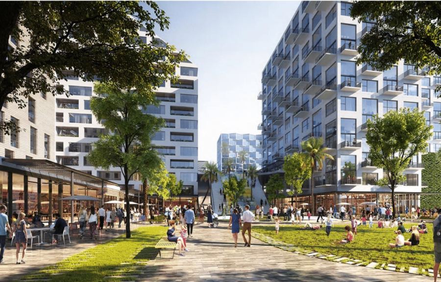
December 22, 2022Renderings have been released for Upland Park, a $1b transit-oriented development planned near the Dolphin Mall.
The development will be “the first truly viable alternative to automobile commuting,”. Upland Park is being purpose-built for integration with the upcoming east-west transit corridor, according to the developer. The community will have expedited access to major employment areas such as Miami International Airport, the Health District, Downtown and Brickell, the developer says. The project site itself is at the planned Dolphin rapid transit station. [caption id="attachment_27290" align="aligncenter" width="1290"] A rendering released by Miami-Dade County showing the BRT service planned on the east-west corridor of the SMART plan[/caption]Once inside the community, residents and workers will enjoy a master-planned walkable neighborhood with built-in traffic solutions, along with resiliency features. The goal is to also have a variety of residence sizes and price points within the neighborhood, catering to “all ages and audiences,” from students to seniors.
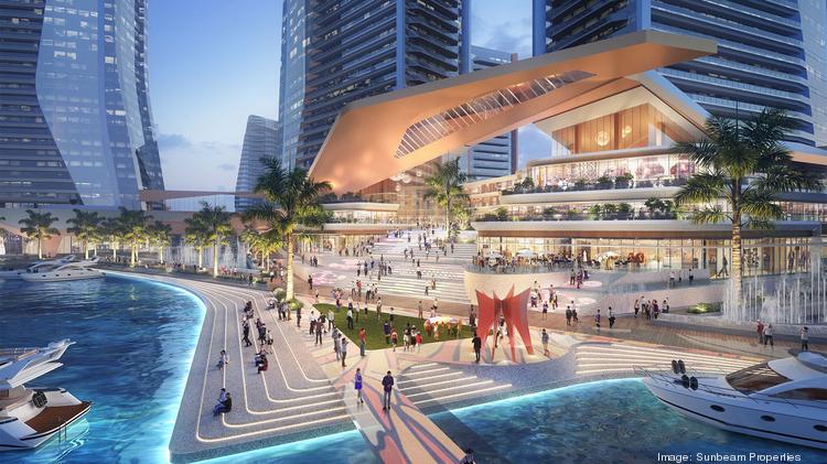
Sunbeam, controlled by the billionaire Ansin family and owner of TV station WSVN, won approval this month to build a massive walkable development in North Bay Village.As part of the approval, a construction permit must be applied for within two years.The project will include 7.3 million square feet, including 8-10 towers rising up to 650 feet, with:1,936 residential units (117 will be workforce housing units)
200,000 square foot Class A HQ office building
300-room luxury hotel with sky restaurant and observation deck (Hyatt signed a letter expressing interest in operating the hotel)
670,000 square feet of commercial, with grocery store, restaurants, entertainment, and retail
a small production studio
a state-of-the-art marina
5,000 parking spacesUniversity of Miami architecture students studied the property to help come up with a plan. The goal is to create a “15-minute city,” with essential needs within walking distance.A baywalk along the waterfront called Island Walk is planned. The developer also wants to build a pedestrian bridge across 79th street (the property spans both sides) and add a water taxi/ferry service.The developer told the SFBJ that the first phase will include two towers with 500 to 600 units, with ground floor grocery, restaurants and retail.Plusurbia is designing the project.
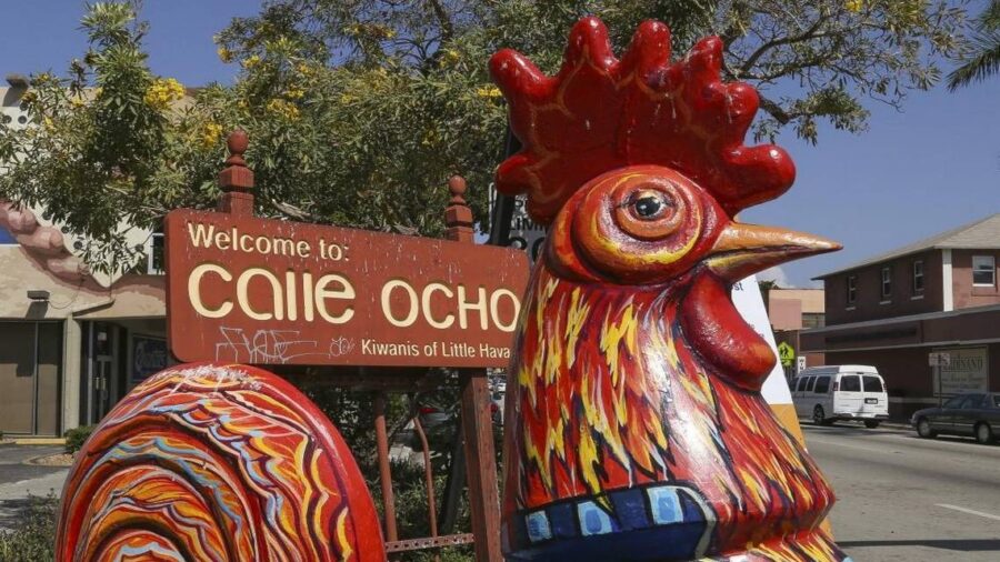
BY OMAR RODRÍGUEZ ORTIZ For the last six years, Florida’s transportation agency has been looking into upgrading Little Havana’s main street, Calle Ocho, to boost safety, encourage alternative transportation and open better access to the Brickell area. Among the enhancements considered, but not adopted, for Southwest Eighth and Seventh streets — two main arteries consisting of six one-way lanes connecting Little Havana and Brickell — are bus lanes, bike lanes and wider sidewalks. Instead, the conclusion of the $3 million study that began in 2016 is a plan to leave the majority of the corridor alone, while adding car-centric modifications near Interstate 95 pending further evaluation, Florida Department of Transportation officials revealed Tuesday at a public information meeting at Miami Dade College’s campus in Little Havana. Calle Ocho falls under the agency’s jurisdiction because it’s a state road.FDOT’s cars-first approach proposals include:▪ Widening the Interstate 95 southbound off-ramp at Southwest Seventh Street.▪ Providing an eastbound to northbound left turn at Southwest Eight Street and Second Avenue intersection.▪ Closing of Southwest Fourth Avenue at Seventh Street.▪ Conversion to two-way traffic at Southwest Fourth and Third avenues between Southwest Sixth and Seventh streets.But several Miami residents who attended the meeting told FDOT leaders they want bike lanes. Carolina Flores, a tour guide who lives in Little Havana, said that a protected bike lane would benefit residents and tourists who ride bicycles and electric scooters. “We should be promoting other modes of transportation,” Flores said.Eric Barton, who lives in Miami, said the plan proposed only looks to further the movement of cars while ignoring other forms of transportation, like bicycles with their own lanes.“This is a plan that perpetuates a mistake,” Barton said. “We have a neighborhood that was built on the backs of immigrants and we put a six-lane highway through the middle of it.” In a four-year span from September 2018 to Aug. 31, Miami police have responded to at least four fatal crashes in the studied area of Southwest Seventh Street, and none on Calle Ocho, according to preliminary police data. In the most recent crash, a woman crossing Southwest Seventh Street at Fifth Avenue on March 14 was struck and killed by a car.Miami City Commissioner Joe Carollo, who represents Calle Ocho and surrounding areas, told the Miami Herald on Wednesday that the city is looking into potential locations where multi-level parking structures could be built. He said the City Commission should receive a report before the end of the year. These parking lots, Carollo said, could allow the city to expand sidewalks by eliminating street parking along Calle Ocho between 12th and 18th avenues. But he said bike-only lanes wouldn’t be used enough to alleviate traffic in the area. “We aren’t China,” Carollo said in Spanish. “This bicycle thing is a nice fairy tale.”At the heart of the issue, according to planner Juan Mullerat, who lives near Calle Ocho, is FDOT’s authority to have a final say on any modifications in the corridor. He said the solution is for Miami to take control of Calle Ocho like in 2014 when the city took over a large portion of Brickell Avenue from FDOT. Officials were frustrated with the inability to lower the speed limit and cull overgrown brush and trees.Read more at: https://www.miamiherald.com/news/local/community/miami-dade/little-havana/article265102319.html#storylink=cpy
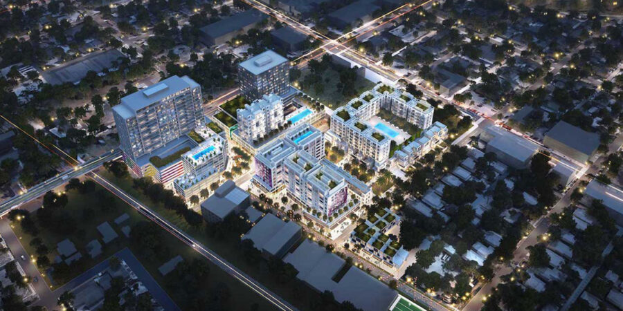
West Palm Beach will be moving in a new direction as developers begin executing on a plan to remake an industrial neighborhood north of Downtown into a food and retail hub. The district, rebranded “Nora,” spans 40 acres in the environs of North Railroad Avenue, and will include 2 million square feet of residential and office development, as well as a hotel.The redevelopment is being led by NDT Development and Place Projects, which spearheaded the reshaping of Miami’s Wynwood district. Urban planning firm PlusUrbia had a hand in creating the major design elements as Downtown expands. Wheelock Street Capital is financing the venture with a budget of up $150 million for the first phase alone, Bloomberg reported.
upstatebizSC: Article
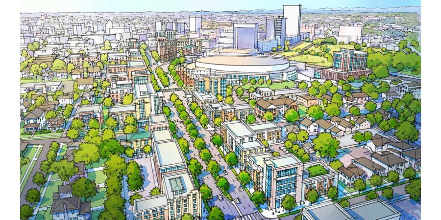
February 24, 2022Plusurbia, the Miami-based urban design group leading the Greenville Gateway master plan project, this week unveiled a reimagined gateway into downtown. Built on community input gathered over several days, the concepts include pedestrian-friendly pathways and greenspace, restaurants, entertainment, sports, and mixed-use developments.The plan was constructed around six key principles: connect, protect, calibrate, reinvest, enhance, and collaborate.The presentation followed four days of public charrettes and open studio hours, during which residents, elected officials, business leaders, and designers gathered to submit ideas. Plusurbia compiled the input into a set of initial concepts for the area that includes East North Street, the Bon Secours Wellness Arena, the Greenville County Law Enforcement Center, Lavinia Street, East Park Avenue, and the Pettigru Historic District.The project spearheaded by DOM360’s Robert and Jennifer Donovan collected 400 survey responses in addition to the input from the charrettes’ attendees.The designers from Plusurbia will continue to collect input from stakeholders via an online survey on the project website at GatewayGreenville.com. Over the next two months, the group will work closely with the city and county to ensure Plusurbia’s recommendations dovetail with the agencies’ current work.Plusurbia will provide recommendations to the City of Greenville by May with the goal of creating a report of stakeholders’ visions and desires for the area that can help guide decision-making for the Greenville Gateway’s future.
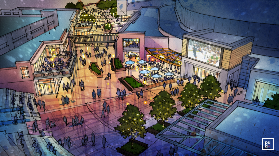
Urban planning group Plusurbia Design revealed what the future of the Greenville Gateway could become on Tues., Oct. 18.After a series of community meetings and a survey earlier this year (which received 479 responses), the urban design group designed a future look for specific areas of the corridor, including:Bon Secours Wellness Arena
East North Street (at the end of I-385 + continuing past The Well)
Pettigru Historic DistrictSome of the most notable changes proposed include transforming East North Street with trees, bike lanes + additional apartments and shifting Bon Secours Wellness Arena’s entrance into a pedestrian-friendly entertainment hub with restaurants and outdoor space.The project, initiated by the owners of local automotive marketing agency DOM360, focuses on a specific corridor of Greenville between these streets:North Church Street
East Washington Street
Atlas Street
Sunflower Street
Richland WayFamiliar places in this area include Bon Secours Wellness Arena, Greenville’s Law Enforcement Center, and the Pettigru Historic District.Plusurbia Design will help develop and implement this vision with private + public funding, and with input from community leaders, organizations, and you.
We use cookies
We use our own and third-party cookies to be able to correctly offer you all the functionalities of the website for analytical purposes. You can accept all cookies by clicking "Accept cookies", obtain more information in our
Website Policyor configure/reject their use by clicking on Settings".
Accept cookies
SettingsBasic cookie informationConfirm preferences
This website uses cookies and/or similar technologies that store and retrieve information when you browse. In general, these technologies can serve very different purposes, such as, for example, recognizing you as a user, obtaining information about your browsing habits or customizing the way in which the content is displayed. The specific uses we make of these technologies are described below. By default, all cookies are disabled, except for the technical ones, which are necessary for the website to work. If you wish to expand the information or exercise your data protection rights, you can consult our Website Policy.
Accept cookiesManage preferencesTechnical and/or necessary cookies
Always active
Technical cookies are those that facilitate user navigation and the use of the different options or services offered by the web such as identifying the session, allowing access to certain areas, filling in forms, storing language preferences, security, facilitating functionalities. (videos, social networks…).
Analytic Cookies
Analysis cookies are those used to carry out anonymous analysis of the behavior of web users and that allow user activity to be measured and navigation profiles to be created with the objective of improving websites.